Tips for trips in the High Tatras
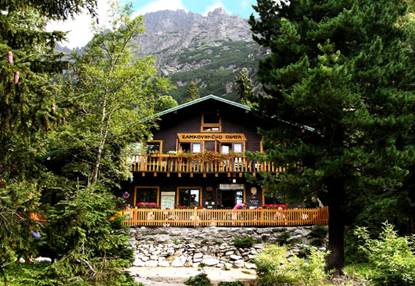
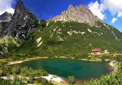
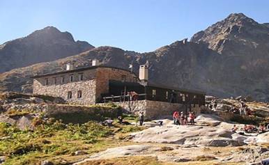
From Skalnaté pleso lake to Zamkovského hut
Difficulty 1/3 Hiking time: 2:55 h.
Basic information
This trail is not so difficult. You can shorten up the route from Tatranská Lomnica to Skalnaté pleso lake by taking a cable car and you can save energy for hiking to Zamkovského hut. Skalnaté pleso is situated in Skalnatá valley under southern slopes of the Lomnický peak.
Detailed information
From Tatranská Lomnica by cable car (interstation Štart) to Skalnaté pleso lake – Rázcestie pri Skalnatej chate – Lomnická vyhliadka – Rázcestie pod Zamkovského chatou – Zamkovského chata – Rázcestie nad Rainerovou chatou – Hrebienok – Starý Smokovec – Tatranská Lomnica
This trail starts in Tatranská Lomnica at starting point of cable cars (850 m), where the cable car will take you through interstation Štart to Skalnaté pleso lake (1 751 m) or you can overcome this distance on foot following the ski slopes. Walking from Tatranská Lomnica to Skalnaté pleso lake will take approximately 1:50 minutes.
From Skalnaté pleso lake you can also take cable car to Lomnický peak or eventually cable car to Lomnické saddle – the highest located ski slope in Slovakia.
There is crossroad close to cable car at Skalnaté pleso lake from which we will start to follow red-marked trail to Zamkovského hut. In a few minutes we will reach cross-road Rázcestie pri Skalnatej chate (1 718 m), where the green-marked trail from Tatranská Lomnica is also linked. If we reach cross-road Rázcestie pod Zamkovského chatou, we can visit Zamkovského hut (1 475 m).
There are many trails marked by various colours from Zamkovského hut to Hrebienok at cross-road Rázcestie pod Zamkovského chatou. You can choose one of them. At cross-road Rázcestie nad Rainerovou chatou (1 304 m) the way back is via teh blue-marked trail to Rainerova hut (1 301 m). There are Studenovodské Waterfalls and Bilíkova hut near Rainerova hut.
From Hrebienok to Starý Smokovec you can come down by walking or you can shorten up the route by taking cog railway. If you arrive to Starý Smokovec, get on a train which will take you to Tatranská Lomnica. Travelling by train takes 15 minutes. This trail can also be performed in the opposite direction.
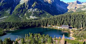
Popradské pleso lake
Difficulty 1/3 Hiking time 3:20 h.
Basic information
It is a quick and easy trail. If we choose variation – start from train station or parking place Popradské pleso, we can use advantage of this trail which is created by asphalt surface, therefore offers great opportunity for families with baby carriages as well as for bikers. Following the blue-marked trail from parking place Popradské pleso or following the red-marked trail from Štrbské pleso, you will reach a beautiful glacial lake called Popradské pleso (1 520 m). Once you reach a lake, you can have a rest in mountain hotel Popradské pleso or at Majláthova hut. Both have restaurants. The way back is via the same route or by following the red-marked route you will reach Štrbské pleso lake (1 352 m).
Detailed information
Štrbské Pleso – Rázcestie pri Popradskom plese (1:25 hod) – Popradské pleso (5 min) – Symbolický cintorín Popradské pleso (30 min) – train stop Popradské pleso (50 min) – Štrbské Pleso (30 min)
From Štrbské Pleso to Popradské pleso we will follow the red-marked trail with starting point at Štrbské pleso lake. If we start from train station, we have to follow the blue-marked trail, go across the bridge above Mlynica river up to cross-road Rázcestie pred Heliosom (1 350 m), where we have to turn right to the forest where we will arrive at cross-road Rázcestie nad Popradským plesom (1 499 m). Here blue and red hiking trails are linked together.
In a few minutes we are located at mountain hotel Popradské pleso (1 500 m). We can have a lunch in hotel Popradské pleso or at Majláthová hut which is located next to mountain hotel Popradské pleso.
If the weather is fine, there are many possibilites for trails at the lake. We have to arrive at cross-road Rázcestie pri Popradskom plese where we can choose the blue-marked trail to Rysy peak, Hincové lakes or Kôprovský peak. On the other side there is starting point to Ostrva saddle following the red-marked trail.
There is Symbolic cemetery near mountain hotel Popradské pleso following the yellow-marked trail. (1 523 m). From cemetery the way back is via cross-road Rázcestie pri Symbolickom cintoríne (1 505 m) to the blue-marked trail leading to train stop Popradské pleso (1:20 h.) or you can come back to Štrbské pleso.
Veľké Biele pleso lake and Zelené pleso lake
Difficulty 1/3 Hiking time 6:00 h.
Basic information
This trail belongs to modest trails partly through Belianske Tatras and partly by easternly part of The High Tatras.
Detailed information
Tatranská kotlina (Belianska cave) – Šumivý prameň (35 min) – Rázcestie Čierna voda (10 min) – Dolina Siedmich prameňov valley – Plesnivec hut (1:15 hod) – Veľké Biele pleso (1:35 hod) – Šalviový prameň (1:10 min) – bus stop Biela voda (55 min)
This trail starts in Tatranská Kotlina near Belianska cave (890 m) where small parking place is located. (760 m). In a few minutes we are at cross-road where blue and green hiking trails are linked together near Šumivý prameň spring. (895 m). After some time you can turn to the green-marked trail leading to Plesnivec hut or you can continue following the blue-marked trail at cross-road Rázcestie Čierna voda (880 m) where also yellow-marked trail is linked. The yellow-marked trail leads through Dolina Siedmich prameňov valley. After 1:15 h. we are at Plesnivec hut (1 290 m), where we can have a lunch.
If you want to continue from Plesnivec hut to Veľké Biele pleso lake, you have to follow the green-marked trail. The trail firstly rapidly ascends to the forest, later we have amazing views to mountain meadows to the valley. There are limestone peaks on the right side and granite peaks on the left side. After short ascending we are reaching Veľké Biele pleso (1 640 m).
There are many possibilities where to go from the lake. You can go to Chata pri Zelenom plese hut or following the blue-marked trail to Kopské saddle from where you can continue following the blue-marked trail to Bielovodská dolina valley to Tatranská Javorina. The trail can be completed at the bus stop Biela voda (following the blue-marked trail). At cross-road Rázcestie pod Šalviovým prameňom (1 060 m) we have to turn to the yellow-marked trail and we will reach bus stop Biela voda (950 m) approximately after one hour. The way back is also possible via the the same route to Tatranská Kotlina (together 6:25 h).
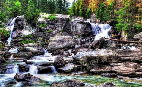
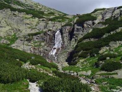
Studenovodské Waterfalls
Difficulty 1/3 Hiking time: 3:00 h.
Basic information
This trail is short and easy with minimal elevation. You can walk this hike at your own pace.
Detailed information
Starý Smokovec – Hrebienok (55 min) – Rázcestie nad Rainerovou chatou – Rainerova chata (20 min) – Obrovský vodopád waterfall (15 min) – Rainerova chata (15 min) – Veľký vodopád waterfall + other waterfalls (20 min) – Tatranská Lesná (55 min)
Following the green-marked trail we will get from Starý Smokovec to Hrebienok (1 285 m). If we do not want to walk, we can shorten up this route by taking cog railway. There are many nature trails from Hrebienok. We can choose the red-marked trail. At cross-road Rázcestie nad Rainerovou chatou (1 304 m) we turn to Rainerova hut (1 301 m). From Rainerova hut we have to continue following the blue-marked trail, later red and green-marked trail. We walk above Veľký Studený potok river and after some time we are at the highest located waterfall from The Studenovodské Waterfalls – Huge waterfall (1 330 m). Next waterfall, the so called Art´s waterfall is hidden in the forest out of nature trail.
Next waterfalls are located following the blue-marked trail which starts at Rainerova hut. Small waterfall with cascade is the highest located waterfall from them.
The way back from these four waterfalls is via the same route following the yellow-marked trail or through Long waterfall (1 160 m), which is situated near by yellow and green-marked trail. After one hour following the yellow-marked trail we will get to Tatranská Lesná.
Alternative to this option is the return to Tatranská Lomnica, where the blue-marked trail leads from Big waterfall. This trail leads firstly through forest under Lomnická vyhliadka, later traverses ski slope. This hiking takes 1:50 h. Another option is to turn from Long waterfall at cross-road of the green and yellow-marked trail to Bilíkova hut. From Bilíkova hut we will get to Hrebienok and from Hrebienok to Starý Smokovec.
Skok Waterfall
Difficulty 1/3 Hiking time 3:10 h.
Basic information
This trail is an easy route at your own walking pace for all age categories when you will see the 30 m high waterfall Skok in Mlynická valley. If you continue walking from waterfall Skok to Bystrá Lávka saddle (2 314 m), you will join the route leading back to Štrbské pleso lake.
Detailed information
Štrbské Pleso – Rázcestie pred Heliosom (15 min) – Vodopád Skok (1:35 min) – Rázcestie pred Heliosom (1:10 hod) – Štrbské Pleso (10 min)
From Štrbské Pleso we start to follow the red-marked trail with starting point at lake. If we start from train station, we have to follow the blue-marked trail and at cross-road Rázcestie pred Heliosom (1 350 m) we have to continue following by the yellow-marked trail to the area of hotel FIS Štrbské Pleso.
We have to walk around Hotel FIS, from where we continue directly toward the forest. The beginning of the forest is visibly destroyed by wind storm but after short time we can see first trees. As this trail contains a lot of serpentine roads, it is very easy. After some time we are entering the area full of dwarf pines through Mlynická valley near Mlynický river. On the left side we can see cable car which connects Solisko and Štrbské pleso lake. On the right side we can see Patria peak. After one and half hour we are arriving at waterfall Skok. The way back is via the same route.
In the summer we can continue over the waterfall Skok to lake, eventually to Bystré saddle which connects Mlynická and Furkotská valley.
To Zelené pleso lake and Sedlo pod Svišťovkou saddle
Difficulty 2/3 Hiking time 7:00 h.
Basic information
It is average difficult trail leading to one of the most beautiful lakes in The High Tatras combined with the passing through Sedlo pod Svišťovkou saddle. You can have a rest at Chata pri Zelenom plese hut.
Detailed information
Parking place Biela voda – Rázcestie nad Matliarmi – Rázcestie pri Šalviovom prameni (1:05 hod) – Kovalčíkova poľana (10 min) – Zelené pleso (1:15 hod) – Sedlo pod Svišťovkou (1:35 min) – Skalnaté Pleso (50 min) – interstation Štart (1:15 hod) – Tatranská Lomnica (50 min)
We can come to Zelené pleso lake from several points. By local bus transport, you reach the starting point of the trek – bus stop and parking place Biela Voda. Following the yellow-marked trail you reach point Rázcestie pri Šalviovom prameni (1 200 m) and Rázcestie pri Kovalčíkovej poľane (1 226 m) where you still have to continue by following the yellow-marked trail and after some time we will arrive at Chata pri Zelenom plese hut (1 551 m), so called Brnčalova hut. From the lake we can continue by following the yellow-marked trail to Jahňací peak or following the red-marked trail to Veľká Svišťovka peak. If we choose Veľká Svišťovka peak, following a red-marked route, we pass through Veľká Svišťovka peak and come to Skalnaté pleso lake.
As hiking from Sedlo pod Svišťovkou saddle (2 023 m) to Veľká Svišťovka peak (2 038 m) takes only a few minutes, we must not forget to turn from the saddle to the peak. Once we reach point Huncovská vyhliadka (1 800 m), we will arrive at Skalnaté pleso lake (1 751 m) in 45 minutes. From Skalnaté pleso lake we descend to Tatranská Lomnica by following the green-marked trail around Skalnatá hut at cross-road Rázcestie pri Skalnatej chate (1 718 m) or we can shorten up this route by taking a cable car from Skalnaté pleso lake to Tatranská Lomnica.
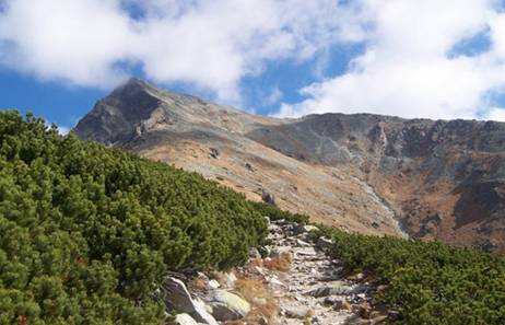
Kriváň peak
Difficulty 2/3 Hiking time 8:35 h.
Basic information
This trail is demanding regarding elevation and belongs to all-day hiking. There is no possibility to have a rest in any hut on the way.
Detailed information
Štrbské Pleso lake – Rázcestie pod Furkotskou dolinou (40 min) – Odbočka na Biely Váh – Jamské pleso lake (30 min) – Rázcestie pod Kriváňom – Kriváň peak (3 hod) – Jamské pleso lake (2:15 hod) – Odbočka na Biely Váh (10 min) – Rázcestie Jamrichovo (50 min) – Štrbské Pleso lake (1:10 hod)
Tthe trail starts at Štrbské pleso behind hotel Solisko at cross-road where we have to start by following the red-marked tral to Rázcestie pod Furkotskou dolinou (1 457 m). From this point we continue beside Odbočka na Biely Váh (1 458 m) up to Jamské pleso lake (1 448 m).
Shortly before Jamské pleso we can find shelter where we can have a rest. From Jamské pleso lake we have to follow the blue-marked trail and shortly after we are arriving at Rázcestie pod Kriváňom (2 140 m), where two marked trails are linked – the blue-marked trail leading from Jamské pleso lake and the green-marked trail which is linked from Tri Studničky at Podbanské. From this cross-road we have to follow only the blue-marked trail to the so called „smaller peak – Malý Kriváň“ (2 335 m). Here the ascending is very steep, after one hour we are reaching the Kriváň peak (2 494 m).
The way back from the peak is via the same route. At Jamské pleso lake we can decide whether to go down following the red-marked trail through Rázcestie pod Furkotskou dolinou (together 7:40 h.) or at Odbočka na Biely Váh to follow the blue-marked trail leading over Biely Váh to cross-road Rázcestie Jamrichovo (1 220 m). From this cross-road we will arrive at Štrbské pleso following the green-marked trail.
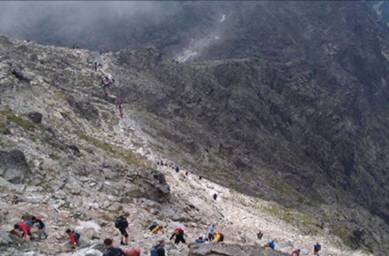
Rysy peak
Difficulty 2/3 Hiking time 8:50 h.
Basic information
This hiking trail is demanding regarding elevation (1 295 m elevation). Common Slovak-Polish Rysy peak is one of the most visited peaks in The High Tatras. It offers a breathtaking view of the surrounding panorama. Under Rysy peak you will find cosy mountain hut where you can have a rest and purchase some refreshments. Back via the same trail.
Detailed information
Popradské Pleso train station – Rázcestie pri Popradskom plese (1:25 hod) – Rázcestie pri Žabom potoku (30 min) – Chata pod Rysmi (2 hod) – Rysy (45 min) – Chata pod Rysmi (35 min) – Rázcestie pri Žabom potoku (1:25 hod) – Rázcestie pri Popradskom plese (20 min) – Popradské pleso (5 min) – Symbolický cintorín Popradské pleso (30 min) – Popradské pleso train station (50 min) – Štrbské Pleso (30 min)
We will start to walk at Popradské pleso train station following the blue-marked trail toward mountain hotel Popradské pleso but a few meters before hotel at cross-road Rázcestie nad Popradským plesom (1 499 m) we have to turn left following the blue-marked trail to Chata pri Popradskom plese hut. At cross-road Rázcestie pri Žabom potoku (1 620 m) we have to continue by following the red-marked trail. We continue around big stone block across the bridge over Žabí potok river and start to ascend to Žabie plesá lakes.
The trail starts to be more steeping from the lakes somewhere ensured by chains. Before going to Rysy peak we can have a rest at Chata pod Rysmi hut (2 250 m). From this hut the trail continues mostly over the ridge to the saddle. The Rysy peak (2 503 m) is a boundary Slovak-Polish peak and it looks like as if it has two peaks. The way back from the peak is via the same route to the cross-road Rázcestie pri Popradskom plese and following the blue-marked trail to Popradské pleso train station or following the red-marked trail to Štrbské pleso lake.
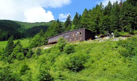
Téryho hut
Difficulty 1/3 Hiking time 7:50 h.
Basic information
It is not so difficult trail to the highest located hut in The High Tatras which is in operation during whole year.
Detailed information
Starý Smokovec – Hrebienok (55 min) – Rázcestie nad Rainerovou chatou – Rainerova chata (20 min) – Rázcestie pod Zamkovského chatou (35 min) – Téryho chata (1:40 hod) – Rázcestie pod Zamkovského chatou (1:15 hod) – Hrebienok – Starý Smokovec
The trail starts in Starý Smokovec (1 010 m), from where we have to arrive at Hrebienok (1 285 m) by walking or we can shorten up this route by taking cog railway to Hrebienok. There are many nature trails marked by various colours from Hrebienok. We can choose the red-marked trail. At cross-road Rázcestie nad Rainerovou chatou (1 304 m) we can turn to Rainerova hut (1 301 m) and have a look to waterfalls or continue directly to Zamkovského hut.
At Zamkovského hut (1 475 m n. m.) we have to continue following the green-marked trail. End of our walking is steeper but in shortly after we are arriving at Téryho hut (2 012 m).
The way back is via the same rout to Zamkovského hut and it takes approximately 1:15 h. From cross-road Rázcestie pod Zamkovského chatou we can go back to Starý Smokovec (1:35 min.) or to Tatranská Lomnica following the red-marked trail.
From Sliezsky dom through Ostrva to Popradské pleso lake
Difficulty 1/3 Hiking time 6:10 h.
Basic information
This trail is of moderate difficulty. You can walk to mountain hotel Sliezsky dom not only along stony forest path but also along asphalt way. Mountain hotel Sliezsky dom lies directly ashore Velické pleso lake. At the end of the trail you can turn off mountain hotel Chata pri Popradskom plese into Symbolic cemetery.
Detailed information
Tatranská Polianka – Rázcestie pri Velickom moste (1 h.) – Sliezsky dom (1:40 h.) – Pod Suchým vrchom – Suchý vrch – Batizovské pleso lake – Sedlo pod Ostrvou – Ostrva – Popradské pleso lake (3:30 h.) – Popradské pleso train station (1:00 h.)
This trail starts in village Tatranská Polianka (1 005 m) either following the green marked-trail or asphalt route marked as cyclotrail. The green-marked trail leads beside cross-roads Velický most (1 304 m) and Velická poľana (1 562 m) up to mountain hotel Sliezsky dom (1 670 m). From Sliezsky dom to Batizovské pleso lake (1 879 m) and mountain hotel Chata pri Popradskom plese we have to follow the red-marked trail.
The trail from Sliezsky dom to Popradské pleso lake leads through cross-roads Pod Suchým vrchom, Batizovské pleso and Sedlo pod Ostrvou. There is a beautiful view from Sedlo pod Ostrvou to surrounding valleys as well as to Popradské pleso lake and mountain hotel Chata pri Popradskom plese.
From Sedlo pod Ostrvou saddle we should not omit short 5-minutes ascending to Ostrva peak with the same way back to Sedlo pod Ostrvou and continue by steep grade with serpentine roads following the red-marked trail to mountain hotel Chata pri Popradskom plese. Near Popradské pleso (1 494 m) we can walk by following the yellow-marked trail to Symbolic cemetery, from where we can join the blue marked-trail leading along the asphalt route to Popradské pleso train station or eventually to Štrbské pleso lake (following the red-marked trail).